ضرب زلزال بقوة 4.7 درجات على مقياس ريختر مناطق واسعة في جنوب إيران، مما أثار حالة من الترقب بين السكان في إقليم هرمزجان والمناطق المحيطة به. وتأتي هذه الهزة الأرضية لتسلط الضوء مجدداً على النشاط الزلزالي المستمر في المنطقة التي تقع على خطوط صدع جيولوجية نشطة.
تفاصيل زلزال جنوب إيران وموقعه
وفقاً للبيانات الصادرة عن المركز الأوروبي المتوسطي لرصد الزلازل، وقعت الهزة الأرضية على عمق 14 كيلومتراً تحت سطح الأرض، وهو ما يفسر شعور السكان بها بوضوح. وقد تركز مركز الزلزال بالقرب من منطقة “بندر لافت”، وامتد تأثيره ليشعر به سكان مدينتي قشم وهرمز، بالإضافة إلى العديد من المناطق الريفية التابعة لمدينة بندر عباس الساحلية الاستراتيجية.
الخسائر وإدارة الأزمات في إقليم هرمزجان
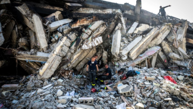
في استجابة سريعة للحدث، صرح المدير العام لإدارة الأزمات في إقليم هرمزجان بأنه لم تُسجل حتى اللحظة أي أضرار مادية أو خسائر بشرية جراء الزلزال. وأكدت السلطات المحلية أن فرق التقييم والمتابعة الميدانية، بما في ذلك فرق الهلال الأحمر الإيراني، تواصل عمليات المسح الشامل للمناطق المتأثرة، خاصة القرى والمناطق الريفية التي قد تكون مبانيها أقل مقاومة للهزات الأرضية.
الخلفية الجيولوجية والتاريخ الزلزالي لإيران
تُعد إيران واحدة من أكثر دول العالم عُرضة للزلازل، حيث تقع جغرافياً فوق منطقة التقاء الصفائح التكتونية العربية والأوراسية. هذا التكوين الجيولوجي يجعل البلاد، وخاصة المناطق الجنوبية والجنوبية الغربية مثل إقليم هرمزجان، مسرحاً مستمراً للنشاط الزلزالي. تاريخياً، شهدت إيران زلازل مدمرة تركت أثراً عميقاً، مثل زلزال “بام” عام 2003 الذي أودى بحياة عشرات الآلاف، مما يجعل أي هزة أرضية، حتى وإن كانت متوسطة القوة مثل هذا الزلزال (4.7 درجات)، مصدر قلق يستدعي استنفاراً فورياً وتفعيلاً لخطط الطوارئ.
الأهمية الاستراتيجية للمناطق المتأثرة وتأثيرها
تكتسب المناطق التي ضربها الزلزال أهمية كبرى على المستويين المحلي والإقليمي. فمدينة “بندر عباس” تُعد الميناء التجاري الأكبر والأهم في إيران، وتلعب دوراً حيوياً في حركة الاستيراد والتصدير. كما أن جزيرة “قشم” هي أكبر جزر الخليج العربي وتتمتع بمكانة اقتصادية وسياحية بارزة. أي تعطل في البنية التحتية في هذه المناطق نتيجة الكوارث الطبيعية قد يؤدي إلى تداعيات اقتصادية محلية، وقد يؤثر بشكل غير مباشر على حركة الملاحة والتجارة الإقليمية نظراً لقربها من مضيق هرمز الاستراتيجي. لذلك، تحرص السلطات دائماً على تطبيق معايير بناء صارمة في المنشآت الحيوية في هذه المحافظة لتقليل المخاطر المحتملة.
خلاصة ومتابعة
في الختام، يبقى الوضع تحت السيطرة والمراقبة المستمرة من قبل مراكز الرصد الجيولوجي وإدارة الكوارث الإيرانية. وتؤكد هذه الأحداث الطبيعية المتكررة على ضرورة تعزيز ثقافة الاستعداد للطوارئ، وتحديث البنية التحتية لتكون أكثر مرونة في مواجهة التحديات الجيولوجية التي تفرضها طبيعة المنطقة، لضمان سلامة الأرواح والممتلكات في المستقبل.