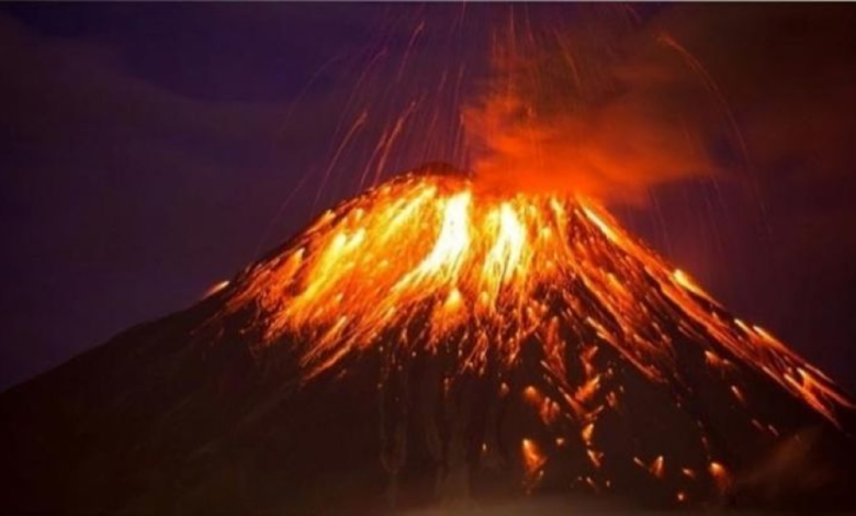
The Indonesian island of Java experienced a significant geological event as local authorities announced eruption of Mount Semeru , prompting a state of high alert in the region. The volcano, one of the most active in the country, spewed a dense cloud of volcanic ash nearly 1,000 meters above the crater, leading to an immediate response from the Indonesian Volcanology Agency to assess the situation and issue necessary warnings to ensure the safety of residents.
Details of the Semeru volcano eruption and lava flow
Indonesia's Agency for Volcanology and Geological Hazard Mitigation reported that the volcanic eruption not only spewed ash but also involved glowing volcanic flows. These flows extended for approximately three kilometers to the southeast, following the course of the Besuk Kupukan River. This intense volcanic activity lasted for about five minutes and was accompanied by a tremor that reached a maximum magnitude of 12 millimeters, reflecting the powerful geological interactions within the magma chambers. A dense ash cloud spread northeast and east, impacting air quality in the surrounding areas.
Precautionary measures and suspension of activities
In response to this dangerous development, Indonesian authorities quickly implemented a series of strict measures to protect lives. The most significant of these was the suspension of all human and economic activity within a five-kilometer radius of the volcano's crater. Authorities also warned residents to stay away from riverbanks, particularly the Besuk Kupukan River, due to the risk of lava flows (lahars) that could form when volcanic ash mixes with rainwater—a common and dangerous phenomenon in the region.
Geological context: Indonesia and the Ring of Fire
To understand the reasons for this frequent activity, one must consider Indonesia's geographical and geological location. The entire Indonesian archipelago lies on the Pacific Ring of Fire, a vast arc of tectonic fault lines characterized by intense seismic and volcanic activity. Indonesia has more than 120 active volcanoes, making it one of the world's most vulnerable countries to natural disasters related to tectonic activity and plate movement.
Historical background of Mount Semeru
Mount Semeru, known locally as “Mahameru” or the Great Mountain, is the highest peak on the island of Java. This volcano has a long and well-documented history of violent eruptions. Perhaps the most recent and notable was the catastrophic eruption in December 2021, which tragically resulted in the loss of dozens of lives, the displacement of thousands of residents, and the destruction of infrastructure in surrounding villages. This tragic history makes any new activity at Mount Semeru a matter of grave concern, requiring close, round-the-clock monitoring by disaster management teams.
Expected impacts locally and regionally
Locally, volcanic ashfall causes significant damage to crops in East Java province, posing a vital agricultural resource, and also presents health risks, particularly respiratory illnesses, to vulnerable populations. Regionally and internationally, if the ash cloud continues to rise and reaches high altitudes, it can pose a serious threat to air traffic, typically requiring airlines to issue warnings to adjust their flight paths to avoid aircraft engines being struck by the ash cloud, which could cause serious mechanical failures.