أصدر المركز الوطني للأرصاد في المملكة العربية السعودية تقريره اليومي عن حالة الطقس المتوقعة ليوم الأحد، مشيراً إلى استمرار التقلبات الجوية على أجزاء واسعة من البلاد. وحذر المركز من فرصة هطول أمطار رعدية مصحوبة برياح نشطة وزخات من البرد، مما يستدعي أخذ الحيطة والحذر.
تفاصيل الحالة الجوية والمناطق المتأثرة
وفقاً لبيان المركز، لا تزال الفرصة مهيأة لهطول أمطار رعدية متوسطة إلى غزيرة، قد تؤدي إلى جريان السيول، وتكون مصحوبة بزخات من البرد ورياح نشطة. وتشمل هذه الحالة أجزاءً من مناطق جازان، عسير، الباحة، مكة المكرمة، والمدينة المنورة. كما تمتد فرصة الأمطار لتشمل أجزاء من منطقة حائل.
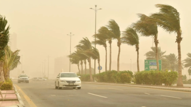
في المقابل، يستمر تأثير الرياح السطحية النشطة المثيرة للأتربة والغبار، والتي تحد من مدى الرؤية الأفقية، على أجزاء من مناطق الجوف، الحدود الشمالية، الشرقية، القصيم، الرياض، ونجران. ودعا المركز المواطنين والمقيمين في هذه المناطق، خاصة مرضى الجهاز التنفسي، إلى توخي الحذر.
السياق المناخي: فترة انتقالية وحساسة
تأتي هذه التقلبات الجوية ضمن الفترة الانتقالية التي تشهدها شبه الجزيرة العربية مع نهاية فصل الربيع وبداية فصل الصيف. تُعرف هذه الفترة محلياً بأسماء مثل “السرايات” أو “المراويح”، وتتميز بتشكل السحب الركامية الرعدية بشكل سريع ومفاجئ، خاصة خلال فترة ما بعد الظهيرة. ويعود سبب هذه الظواهر إلى التقاء الكتل الهوائية المختلفة، الدافئة الرطبة والباردة الجافة، مما يخلق حالة من عدم الاستقرار الجوي تؤدي إلى هطول أمطار غزيرة في نطاقات جغرافية ضيقة ولفترات قصيرة، وغالباً ما تكون مصحوبة برياح هابطة قوية وعواصف ترابية.
الأهمية والتأثيرات المتوقعة
تحمل هذه الأمطار أهمية كبرى في تغذية الخزانات الجوفية والسدود في المملكة، خاصة في المناطق الجنوبية والغربية الجبلية، مما يدعم القطاع الزراعي ومصادر المياه. ومع ذلك، فإن غزارتها المفاجئة تشكل خطراً يتمثل في تشكل السيول المنقولة في الأودية والشعاب، وهو ما يستدعي متابعة مستمرة لتحذيرات الدفاع المدني والجهات المعنية والابتعاد عن مجاري السيول. على الصعيد الصحي، تزيد العواصف الترابية من حالات الحساسية وأمراض الجهاز التنفسي، بينما تؤثر على حركة النقل البري والجوي بسبب انخفاض الرؤية.
حالة البحر وحركة الملاحة
أوضح تقرير الأرصاد أن حالة البحرين ستكون كالتالي:
البحر الأحمر
- الرياح السطحية: شمالية غربية إلى غربية بسرعة 15-35 كم/ساعة على الجزأين الشمالي والأوسط، تصل إلى 50 كم/ساعة باتجاه خليج العقبة. وتكون جنوبية شرقية إلى جنوبية غربية بسرعة 10-32 كم/ساعة على الجزء الجنوبي، تصل إلى 45 كم/ساعة باتجاه مضيق باب المندب.
- ارتفاع الموج: من متر إلى مترين على الجزأين الشمالي والأوسط، ويصل إلى أعلى من مترين باتجاه خليج العقبة. ومن نصف المتر إلى متر ونصف على الجزء الجنوبي، يصل إلى مترين باتجاه مضيق باب المندب.
- حالة البحر: متوسط الموج على الجزأين الشمالي والأوسط، ويصل إلى مائج باتجاه خليج العقبة، بينما يكون خفيف إلى متوسط الموج على الجزء الجنوبي.
الخليج العربي
- الرياح السطحية: شمالية غربية إلى شمالية على الجزأين الشمالي والأوسط، وشمالية غربية إلى غربية على الجزء الجنوبي بسرعة 20-40 كم/ساعة، تصل إلى 45 كم/ساعة على الجزء الأوسط.
- ارتفاع الموج: من متر إلى مترين.
- حالة البحر: متوسط الموج.