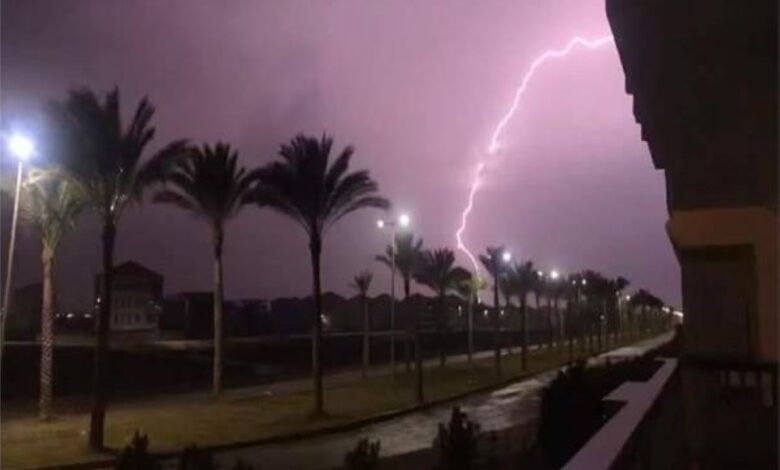
أصدر المركز الوطني للأرصاد في المملكة العربية السعودية تقريره المفصل عن حالة الطقس المتوقعة ليوم السبت، محذراً من استمرار التقلبات الجوية التي تشهدها البلاد. وتشير التوقعات إلى هطول أمطار رعدية، قد تكون متوسطة إلى غزيرة، مصحوبة بزخات من البرد ونشاط في الرياح السطحية المثيرة للأتربة والغبار، مما يحد من مدى الرؤية الأفقية على أجزاء واسعة من المملكة.
ووفقاً لبيان المركز، تشمل المناطق المتأثرة بهذه الحالة الجوية كلاً من جازان، وعسير، والباحة، ومكة المكرمة، والمدينة المنورة، بالإضافة إلى مناطق حائل، والقصيم، والرياض. ويُتوقع أن تمتد هذه التأثيرات لتشمل أجزاء من مناطق الجوف، والحدود الشمالية، والشرقية، ونجران، حيث ستكون الرياح النشطة هي السمة الأبرز، مما يزيد من كثافة الغبار ويؤثر على مرضى الجهاز التنفسي وقائدي المركبات على الطرق السريعة.
السياق المناخي للتقلبات الجوية
تأتي هذه الظروف الجوية ضمن السياق المناخي لفترة الربيع في المملكة، والتي تُعرف محلياً بفترة “السرايات” أو “مراويح الصيف”. تتميز هذه الفترة الانتقالية بين فصلي الشتاء والصيف بارتفاع نسبة عدم الاستقرار في طبقات الجو العليا، نتيجة التقاء الكتل الهوائية الباردة القادمة من الشمال مع الكتل الهوائية الدافئة والرطبة القادمة من الجنوب. هذا الالتقاء يخلق الظروف المثالية لتكون السحب الركامية الرعدية التي تتسبب في هطول أمطار غزيرة ومفاجئة، وغالباً ما تكون مصحوبة بالبرد والرياح الهابطة الشديدة.
الأهمية والتأثيرات المتوقعة
على الصعيد المحلي، تحمل هذه الأمطار أهمية كبرى في تغذية الخزانات الجوفية والسدود، ودعم القطاع الزراعي في المملكة التي تعتمد بشكل كبير على الموارد المائية المحدودة. ومع ذلك، فإنها تشكل تحدياً كبيراً للسلامة العامة. وقد أصدرت المديرية العامة للدفاع المدني تحذيرات متكررة للمواطنين والمقيمين بضرورة أخذ الحيطة والحذر، والابتعاد عن مجاري الأودية والسيول، وتجنب المناطق المنخفضة. كما يُنصح قائدي المركبات بتوخي الحذر الشديد بسبب انخفاض الرؤية واحتمالية انزلاق الطرق. ومن المتوقع أن تؤثر هذه الأحوال الجوية على حركة الملاحة الجوية في بعض المطارات الإقليمية، بالإضافة إلى التأثير على الأنشطة الخارجية والفعاليات المفتوحة.
حالة البحر الأحمر
- الرياح السطحية: شمالية غربية إلى شمالية بسرعة 20-40 كم/ساعة على الجزأين الشمالي والأوسط، قد تصل إلى 48 كم/ساعة باتجاه خليج العقبة. وتكون شمالية غربية إلى غربية بسرعة 10-30 كم/ساعة على الجزء الجنوبي.
- ارتفاع الموج: من متر إلى مترين على الجزأين الشمالي والأوسط، ويصل إلى أكثر من مترين باتجاه خليج العقبة. ومن نصف المتر إلى متر ونصف على الجزء الجنوبي.
- حالة البحر: متوسط الموج على الجزأين الشمالي والأوسط، وقد يكون مائجاً باتجاه خليج العقبة. خفيف إلى متوسط الموج على الجزء الجنوبي.
حالة الخليج العربي
- الرياح السطحية: شمالية غربية إلى شمالية على الجزأين الشمالي والأوسط، وشمالية غربية إلى غربية على الجزء الجنوبي، بسرعة تتراوح بين 20-40 كم/ساعة.
- ارتفاع الموج: من متر إلى مترين.
- حالة البحر: متوسط الموج.