توقعات حالة الطقس في السعودية اليوم
أعلن المركز الوطني للأرصاد في تقريره اليومي عن تفاصيل حالة الطقس في السعودية لهذا اليوم الثلاثاء، محذراً من تقلبات جوية ملحوظة تؤثر على عدة مناطق. وتوقع التقرير أن توالي درجات الحرارة العظمى ارتفاعها الملموس على أجزاء واسعة من مناطق غرب المملكة، بالإضافة إلى أجزاء من المنطقة الشرقية. وتأتي هذه التوقعات في ظل التغيرات المناخية الموسمية التي تشهدها شبه الجزيرة العربية.
السياق المناخي وتأثير العوامل الجوية
تاريخياً، تُعرف المملكة العربية السعودية بمناخها الصحراوي الجاف، حيث ترتفع درجات الحرارة بشكل كبير خلال فترات الانتقال بين الفصول وفي فصل الصيف. وتنشط في هذه الأوقات الرياح الموسمية التي تُعرف محلياً وإقليمياً بقدرتها على إثارة العواصف الرملية. ويعد هذا النمط المناخي جزءاً من طبيعة المنطقة، إلا أن متابعة تقارير الأرصاد تظل ضرورية لتجنب الآثار السلبية لهذه الظواهر على الحياة اليومية والاقتصاد المحلي، خاصة فيما يتعلق بحركة النقل البري والجوي.
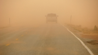
رياح نشطة وأتربة مثارة تضرب عدة مناطق
وأشار المركز الوطني للأرصاد إلى استمرار تأثير الرياح النشطة المثيرة للأتربة والغبار، والتي قد تؤدي إلى انعدام أو شبه انعدام في مدى الرؤية الأفقية. وتشمل هذه الحالة الجوية أجزاء من مناطق الشرقية، الحدود الشمالية، الجوف، تبوك، حائل، القصيم، المدينة المنورة، ومكة المكرمة، مع امتداد تأثيرها ليصل إلى أجزاء من منطقة الرياض. وتتطلب هذه الظروف أخذ أقصى درجات الحيطة والحذر، خاصة لمرضى الجهاز التنفسي وقائدي المركبات على الطرق السريعة.
حالة الملاحة البحرية: البحر الأحمر والخليج العربي
حالة البحر الأحمر
أوضح التقرير تفاصيل الحالة البحرية، حيث تكون الرياح السطحية على البحر الأحمر شمالية إلى شمالية غربية على الجزأين الشمالي والأوسط بسرعة تتراوح بين 15 إلى 30 كم/ساعة. بينما تكون جنوبية غربية إلى شمالية غربية على الجزء الجنوبي بسرعة 10 إلى 25 كم/ساعة. ويتراوح ارتفاع الموج من نصف المتر إلى متر ونصف على الجزأين الشمالي والأوسط، ومن نصف المتر إلى متر على الجزء الجنوبي، لتكون حالة البحر خفيفة إلى متوسطة الموج، مما يسمح بحركة الملاحة البحرية بحذر.
حالة الخليج العربي
أما في الخليج العربي، فتكون الرياح السطحية جنوبية شرقية إلى جنوبية غربية على الجزأين الشمالي والأوسط بسرعة 10 إلى 25 كم/ساعة، وغربية إلى شمالية غربية على الجزء الجنوبي بسرعة 15 إلى 35 كم/ساعة. ويسجل ارتفاع الموج من نصف المتر إلى متر على الجزأين الشمالي والأوسط، ومن نصف المتر إلى متر ونصف على الجزء الجنوبي، وحالة البحر خفيفة إلى متوسطة الموج.
تنبيهات خاصة للمنطقة الشرقية
أصدر المركز تنبيهات خاصة بشأن المنطقة الشرقية، حيث تشهد عوالق ترابية وأتربة مثارة خلال ساعات الصباح الباكر. وتستمر هذه العوالق حتى الساعة 9 صباحاً على مدن الجبيل، الخبر، الدمام، القطيف، رأس تنورة، الأحساء، العديد، وبقيق، مصحوبة بتدني في مدى الرؤية الأفقية يتراوح بين 3 إلى 5 كيلومترات.
في حين تستمر الأتربة المثارة حتى الساعة 8 صباحاً على حفر الباطن، الخفجي، وقرية العليا، وتتمثل التأثيرات المصاحبة في رياح نشطة وتدني مماثل في مدى الرؤية الأفقية. وتؤكد هذه التحذيرات على أهمية متابعة النشرات الجوية لضمان السلامة العامة وتفادي أي حوادث مرورية أو أزمات صحية طارئة.