مقدمة عن حالة الطقس اليوم في المملكة
في ظل التقلبات الجوية التي تشهدها المملكة العربية السعودية خلال الفترات الانتقالية للمواسم، أصدر المركز الوطني للأرصاد تقريره المفصل عن حالة الطقس اليوم الثلاثاء. وتلعب هذه التقارير الدورية دوراً حيوياً في تعزيز السلامة العامة، حيث تتيح للمواطنين والمقيمين والجهات المعنية اتخاذ التدابير الاستباقية اللازمة للتعامل مع الظواهر الجوية المتطرفة، بما يتماشى مع جهود المملكة في حماية الأرواح والممتلكات.
خريطة هطول الأمطار والمناطق المتأثرة بالسيول
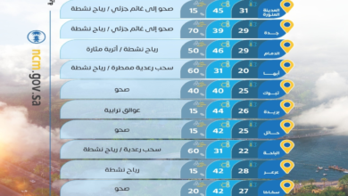
أوضح التقرير أن الفرصة لا تزال مهيأة بشكل كبير لهطول أمطار رعدية تتراوح حدتها بين المتوسطة والغزيرة. ومن المتوقع أن تؤدي هذه الهطولات إلى جريان السيول في الأودية والشعاب، وهي ظاهرة طبيعية تتطلب الحذر الشديد. وتتركز هذه الحالة الجوية، مصحوبة بزخات من البرد، على أجزاء واسعة من مناطق:
- الرياض
- المنطقة الشرقية
- نجران
في المقابل، يُتوقع أن تشهد أجزاء من مناطق القصيم، حائل، وتبوك هطول أمطار خفيفة، مما يساهم في تلطيف الأجواء وانخفاض درجات الحرارة نسبياً في تلك الأنحاء.
تأثير الرياح النشطة وموجات الغبار
إلى جانب الأمطار، حذر المركز من استمرار تأثير الرياح السطحية النشطة. وتكمن خطورة هذه الرياح في إثارتها للأتربة والغبار، مما يؤدي إلى تدني مستوى الرؤية الأفقية، وهو ما يؤثر بشكل مباشر على حركة السير على الطرق السريعة المفتوحة. ويشمل تأثير هذه الرياح المثير للغبار الأجزاء المذكورة سابقاً، بالإضافة إلى أجزاء من منطقتي المدينة المنورة ومكة المكرمة. كما تتهيأ الفرصة لتكون السحب الرعدية الممطرة والمصحوبة برياح نشطة على أجزاء من المرتفعات الجنوبية الغربية للمملكة، والتي تتميز بطبيعتها الجبلية التي تزيد من سرعة تشكل السحب الركامية.
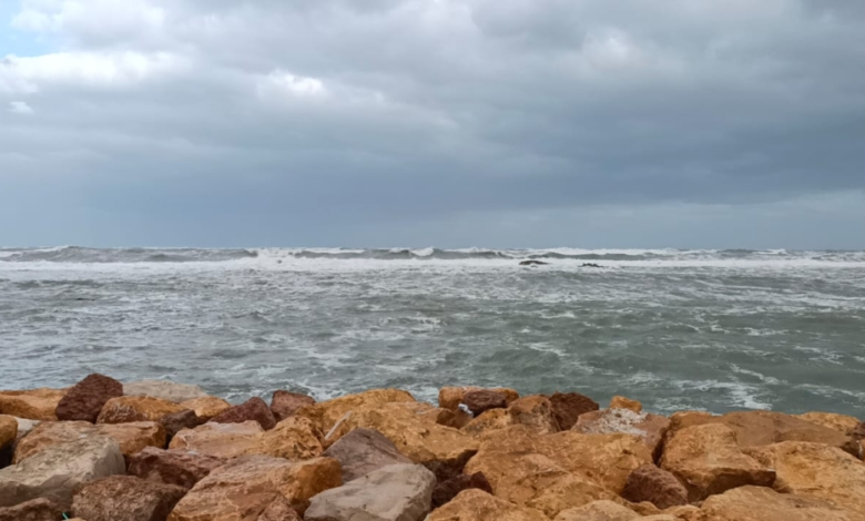
حالة الملاحة البحرية: البحر الأحمر والخليج العربي
نظراً لأهمية الملاحة البحرية وحركة الصيد والتجارة، فصّل التقرير حالة البحر في السواحل السعودية، والتي تتأثر بشكل مباشر بالمنخفضات الجوية:
حالة البحر الأحمر
- الرياح السطحية: تهب رياح شمالية غربية إلى شمالية بسرعة تتراوح بين 15 إلى 34 كم/ساعة.
- ارتفاع الموج: يتراوح من نصف المتر إلى متر ونصف.
- حالة البحر: خفيف إلى متوسط الموج، مما يعتبر مستقراً نسبياً للأنشطة البحرية المعتادة.
حالة الخليج العربي
- الرياح السطحية: جنوبية شرقية إلى جنوبية غربية على الجزء الشمالي، وشمالية شرقية إلى جنوبية شرقية على الجزأين الأوسط والجنوبي بسرعة 15-32 كم/ساعة. وقد تتصاعد سرعتها لتصل إلى 55 كم/ساعة مع تكون السحب الرعدية الممطرة.
- ارتفاع الموج: من نصف المتر إلى متر ونصف، وقد يتجاوز المترين في حال تكون السحب الرعدية.
- حالة البحر: خفيف إلى متوسط الموج، ولكنه يتحول إلى مائج ومضطرب مع السحب الرعدية، مما يستدعي أخذ الحيطة والحذر من قبل الصيادين ومرتادي البحر.
إرشادات السلامة والتأثير المجتمعي
تؤثر هذه التغيرات المناخية بشكل مباشر على الحياة اليومية. وتشدد الجهات المختصة، وفي مقدمتها المديرية العامة للدفاع المدني، على ضرورة الابتعاد عن بطون الأودية ومجاري السيول أثناء هطول الأمطار، وعدم المجازفة بعبورها. كما يُنصح بمتابعة التحديثات المستمرة الصادرة عن المركز الوطني للأرصاد عبر قنواته الرسمية لضمان السلامة العامة وتجنب أي حوادث ناجمة عن الانزلاقات الأرضية أو انعدام الرؤية.