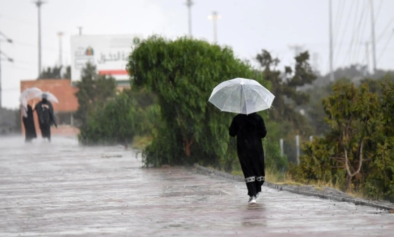
Saudi Arabia weather: Tarif records zero temperatures, heavy rain and flash floods expected
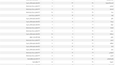
Saudi Arabia experienced sharp weather fluctuations on Sunday, January 25th, with the lowest temperature recorded in the province of Tarif, nearing the freezing point, a clear indication of the deepening cold air mass in the northern regions. In a more detailed analysis of temperatures, Qurayyat recorded 1 degree Celsius, while Sakaka and Tabuk both reached 3 degrees Celsius, Arar recorded 4 degrees, and Hail and Rafha both reached 6 degrees Celsius.
Rainfall details and warnings
The National Center for Meteorology issued its daily report indicating continued atmospheric instability, forecasting moderate to heavy thunderstorms. The center warned that these storms could lead to flash floods in valleys and ravines, accompanied by hail. This weather pattern is expected to be particularly concentrated in parts of the Qassim, Northern Borders, and Eastern Provinces, as well as the northern parts of the Riyadh region.
Along with the rainfall, temperatures are expected to drop significantly, accompanied by strong surface winds that will stir up dust and sand. This activity may lead to reduced or near-zero horizontal visibility in open areas and on highways, particularly in the aforementioned regions, extending to parts of the Tabuk and Madinah regions, especially their coastal areas.
climatic context and the impact of air masses
This cold wave and weather fluctuations are a natural part of the Kingdom's winter climate, as the northern and central regions are typically affected by Siberian high-pressure systems or polar air masses moving across the Mediterranean. Areas like Tarif and Qurayyat serve as the Kingdom's northern gateway to these cold fronts, explaining why they experience the lowest temperatures compared to other regions. This time of year marks the peak of the winter rainy season (known locally as "al-Deem") in the central and eastern regions, which positively impacts water reserves and natural pastures, despite the potential risks of flash floods.
Sea conditions and navigation forecast
Regarding maritime navigation, the center explained that the Red Sea is experiencing northwesterly to northerly surface winds in its northern and central parts, shifting to southeasterly and southwesterly in the south, with speeds reaching up to 50 km/h and the formation of thunderstorms. Wave heights range between one and two and a half meters, making sea conditions rough in areas of thunderstorms.
In the Arabian Gulf, surface winds are active at speeds of up to 55 km/h, coinciding with rain-bearing thunderclouds, with waves reaching up to two and a half meters high, which calls for caution and vigilance for seafarers and fishermen in those areas.