New Tumair Observatory: First sighting of the Ramadan crescent and advanced equipment
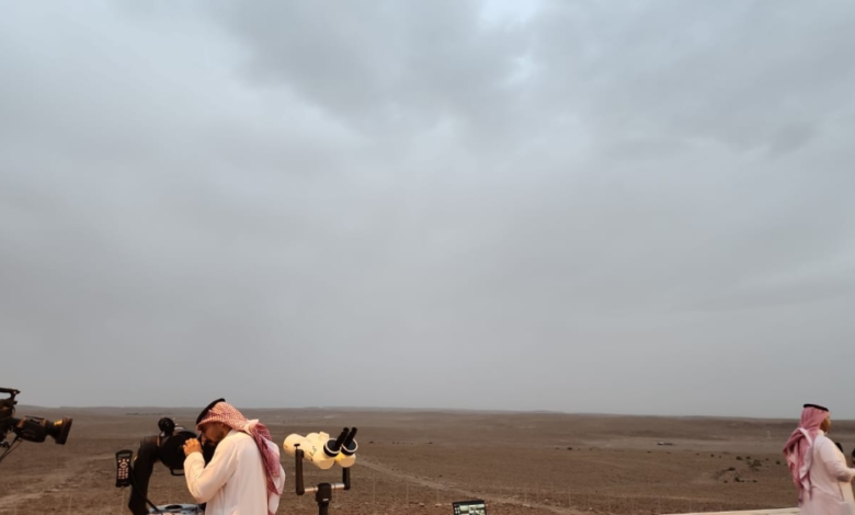
The newly established Tumair Observatory witnessed a historic event with the first sighting of the crescent moon for the holy month of Ramadan from its modern location, following its official inauguration by His Royal Highness Prince Dr. Faisal bin Abdulaziz bin Ayyaf, Mayor of Riyadh. This step represents a qualitative leap in the mechanisms for observing the crescent moon in the Kingdom of Saudi Arabia, as the site has transformed from a mere traditional observation point into a fully integrated facility designed according to the latest scientific and organizational standards.
The new observatory boasts a strategic geographical location, carefully chosen to ensure a clear horizon free from natural obstructions or light pollution, thus enhancing the accuracy of both legal and astronomical observations. The facility includes advanced equipment such as an upper platform equipped for observers, a dedicated office for the sighting committee affiliated with the Supreme Court, and reception and waiting areas that provide a comfortable and organized environment for specialists and visitors, facilitating the documentation and reporting process to the relevant authorities with speed and high accuracy.
Historically, the selection of Tumair for this project is not accidental, but rather an extension of a long-standing tradition for which the city, long known as the "Capital of Astronomy," is renowned. The King Abdulaziz Foundation has documented a long history of Tumair's inhabitants observing the crescent moon and stars, taking advantage of their keen eyesight and the region's elevated and pristine terrain. Previously, observations were conducted outdoors in potentially harsh weather conditions. However, this new project aims to preserve and develop this heritage in line with the urban and technological advancements taking place in the Kingdom.
The establishment of this observatory exemplifies a successful community partnership between the government and non-profit sectors. The project was implemented through collaboration between the Riyadh Municipality and the Ibrahim bin Abdulmohsen Al-Sultan Charitable Foundation. This partnership reflects a commitment to supporting initiatives with a knowledge-based and ethical dimension, and to achieving the goals of the Kingdom's Vision 2030 in promoting volunteer work and community service.
Regionally and internationally, this event is of paramount importance given the Kingdom of Saudi Arabia's position as a reference point for the Islamic world in determining the beginnings of the lunar months and religious rites. The presence of advanced observatories like the Tumair Observatory enhances confidence in the accuracy of official announcements, combining traditional sightings with precise astronomical calculations into a unified system, thus minimizing the possibility of error and ensuring consistency in major religious occasions.