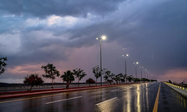
تحذيرات من تقلبات جوية واسعة في المملكة
أصدر المركز الوطني للأرصاد في المملكة العربية السعودية تقريره المفصل عن حالة الطقس المتوقعة ليوم الجمعة، محذراً من استمرار حالة عدم الاستقرار الجوي على معظم مناطق المملكة. وتشير التوقعات إلى هطول أمطار رعدية متفاوتة الشدة، قد تصل إلى الغزيرة، مما يزيد من احتمالية جريان السيول في عدد من المناطق، مصحوبة بزخات من البرد ورياح نشطة تحد من مدى الرؤية الأفقية.
المناطق المتأثرة بالحالة المطرية
وفقاً لبيان المركز، لا تزال الفرصة مهيأة لهطول أمطار رعدية تتراوح شدتها بين المتوسطة والغزيرة، تؤدي إلى جريان السيول، على أجزاء واسعة من مناطق جازان، عسير، الباحة، ومكة المكرمة. كما تمتد الحالة المطرية لتشمل مناطق المدينة المنورة، حائل، القصيم، والرياض، بالإضافة إلى الأجزاء الشمالية من المنطقة الشرقية. ويصاحب هذه الأمطار نشاط في الرياح السطحية وزخات من البرد، مما يستدعي أخذ الحيطة والحذر.
السياق المناخي: موسم المراويح والسرايات
تأتي هذه التقلبات الجوية ضمن السياق المناخي المعتاد لفصل الربيع في شبه الجزيرة العربية، وهي فترة انتقالية تُعرف محلياً بـ “موسم المراويح” أو “السرايات”. تتميز هذه الفترة بارتفاع نسبة الرطوبة في طبقات الجو العليا وتيارات هوائية غير مستقرة، مما يخلق ظروفاً مثالية لتكون السحب الركامية الرعدية الكثيفة التي تتسبب في هطول أمطار غزيرة خلال فترة زمنية قصيرة، وهو ما يفسر التحذيرات المتكررة من تشكل السيول المفاجئة في الأودية والشعاب.
التأثيرات المتوقعة وأهمية الاستجابة للتحذيرات
يترتب على هذه الحالة الجوية تأثيرات مباشرة على الحياة اليومية، حيث يُتوقع أن تؤثر على حركة السير في المدن والطرق السريعة. وقد أصدرت المديرية العامة للدفاع المدني تحذيرات للمواطنين والمقيمين بضرورة توخي الحذر والابتعاد عن مجاري الأودية والسيول، وتجنب المناطق المنخفضة وتجمعات المياه. كما تؤثر الرياح النشطة المثيرة للأتربة والغبار على مرضى الجهاز التنفسي وتحد من مدى الرؤية الأفقية، مما يتطلب حذراً إضافياً من السائقين. على الصعيد الإيجابي، تساهم هذه الأمطار في تغذية الخزانات الجوفية وزيادة منسوب المياه في السدود، مما يعود بالنفع على القطاع الزراعي والمخزون المائي للمملكة.
حالة البحرين الأحمر والعربي
البحر الأحمر: من المتوقع أن تكون الرياح السطحية شمالية غربية إلى شمالية بسرعة تتراوح بين 20 و 40 كم/ساعة على الجزأين الشمالي والأوسط، وقد تصل إلى 50 كم/ساعة باتجاه خليج العقبة. أما على الجزء الجنوبي، فتكون الرياح بسرعة 12-30 كم/ساعة. ويتراوح ارتفاع الموج من متر إلى مترين على الجزأين الشمالي والأوسط، ويصل إلى أكثر من مترين باتجاه خليج العقبة، بينما يكون من نصف المتر إلى متر ونصف على الجزء الجنوبي. وتكون حالة البحر متوسطة الموج إلى مائج شمالاً، وخفيفة إلى متوسطة الموج جنوباً.
الخليج العربي: تكون الرياح السطحية شمالية غربية إلى شمالية بسرعة 15-40 كم/ساعة على الجزأين الشمالي والأوسط، وقد تتجاوز 50 كم/ساعة مع تكون السحب الرعدية الممطرة. وعلى الجزء الجنوبي، تكون الرياح شمالية غربية إلى جنوبية غربية بسرعة 12-35 كم/ساعة. ويتراوح ارتفاع الموج من نصف المتر إلى متر ونصف، وقد يصل إلى مترين ونصف مع السحب الرعدية شمالاً. وتكون حالة البحر خفيفة إلى متوسطة الموج، وقد تموج مع تكون السحب الرعدية.