أعلن المركز الوطني للأرصاد في المملكة العربية السعودية عن إطلاق خدمة متطورة تعتمد على تقنيات الفضاء، تتمثل في بدء إصدار خرائط مناخية متخصصة لتوزيعات الأمطار. تأتي هذه الخطوة الاستراتيجية ضمن جهود المركز الحثيثة الرامية إلى تطوير أدوات الرصد والتحليل المناخي، وتعزيز منظومة الإنذار المبكر لحماية الأرواح والممتلكات.
السياق التاريخي والتطور التقني في الأرصاد
تاريخياً، شهدت المملكة العربية السعودية تطوراً ملحوظاً ومستمراً في قطاع الأرصاد الجوية. فبعد أن كان الاعتماد يقتصر في العقود الماضية على محطات الرصد الأرضية التقليدية، انتقلت المملكة اليوم إلى توظيف أحدث تقنيات الأقمار الصناعية العالمية. ويتوافق هذا التطور التقني الكبير مع مستهدفات رؤية السعودية 2030، التي تولي اهتماماً بالغاً بالاستدامة البيئية، وتحسين جودة الحياة، ورفع مستوى الجاهزية للتعامل مع التغيرات المناخية التي يشهدها العالم بأسره. إن التحول نحو استخدام البيانات الفضائية يعكس حرص القيادة على تسخير التكنولوجيا الحديثة لمواجهة التحديات البيئية والمناخية.
تفاصيل الخدمة المناخية الجديدة
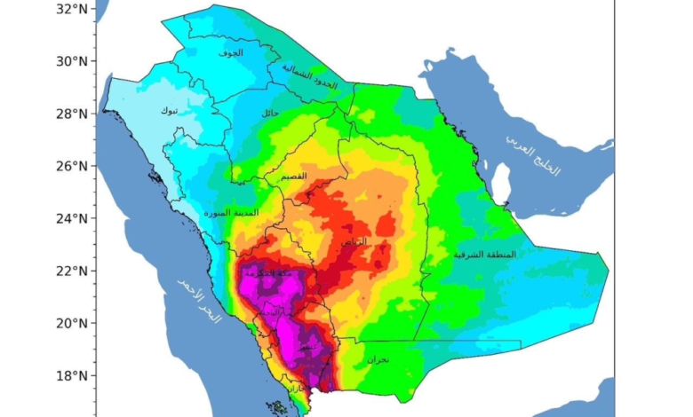
وفي هذا الإطار، أصدر المركز الوطني للأرصاد خريطة مناخية دقيقة توضح توزيعات الأمطار لشهر أبريل، مستنداً إلى قاعدة بيانات تاريخية شاملة تمتد للفترة من عام 1998 وحتى عام 2025. يعتمد هذا التحليل العميق على بيانات الأقمار الصناعية المتقدمة التي يقوم المركز بتحليلها ومعالجتها باستخدام أحدث الخوارزميات والنماذج العددية، مما يوفر قراءة دقيقة وشاملة للأنماط المناخية المتوقعة.
توزيع هطول الأمطار جغرافياً
أظهرت الخرائط المناخية الحديثة تركز هطول الأمطار بكميات أعلى خلال شهر أبريل على المرتفعات الجنوبية الغربية والغربية من المملكة، وهي مناطق تُعرف بطبيعتها الطبوغرافية الجبلية التي تساهم في تشكل السحب الرعدية الممطرة بكثافة. كما بينت الخرائط امتداد هذه الهطولات، ولكن بكميات أقل، نحو أجزاء من وسط المملكة. في حين تشهد بقية المناطق هطولات مطرية بدرجات متفاوتة، مما يعكس التنوع المناخي والجغرافي الكبير الذي تتمتع به أراضي المملكة العربية السعودية.
تعزيز منظومة الإنذار المبكر والسلامة العامة
تُعد هذه الخرائط المناخية المبنية على بيانات الأقمار الصناعية إحدى أهم الأدوات الفاعلة والداعمة لمنظومة الإنذار المبكر. فهي تمكّن الجهات الحكومية ذات العلاقة، مثل الدفاع المدني ووزارة النقل والبلديات، من اتخاذ الاحتياطات والتدابير الاستباقية اللازمة للتعامل مع الحالات المطرية الشديدة وجريان السيول. كما تلعب هذه البيانات دوراً حيوياً في دعم القطاع الزراعي من خلال تحديد مواسم الزراعة المناسبة، وتساعد في تخطيط البنية التحتية وتصميم شبكات تصريف مياه الأمطار بطرق علمية مدروسة. ويسهم ذلك بشكل مباشر في رفع مستوى الجاهزية، والتعامل الفعّال مع مختلف الظواهر الجوية المتطرفة قبل وقوعها.
التأثير الإقليمي والدولي
على الصعيد الإقليمي والدولي، يعزز هذا الإنجاز التقني مكانة المملكة العربية السعودية كدولة رائدة في مجال الأرصاد الجوية في منطقة الشرق الأوسط. إن توفير منتجات مناخية متقدمة مبنية على أدق البيانات والتحليلات العلمية لا يخدم الداخل السعودي فحسب، بل يساهم في إثراء قواعد البيانات المناخية العالمية، ويدعم الجهود الدولية والإقليمية في دراسة ظاهرة التغير المناخي. تأتي هذه الخطوة تماشياً مع التوجهات الاستراتيجية للمركز لتوفير معلومات موثوقة تدعم اتخاذ القرار وتعزز مستويات السلامة العامة للمجتمع بأسره.