زلزال عنيف يضرب شرق إندونيسيا وتحذيرات من تسونامي
ضرب زلزال بحري عنيف بلغت قوته 7.4 درجات على مقياس ريختر منطقة شرق إندونيسيا فجر يوم الخميس، مما أثار حالة من الاستنفار والمراقبة الجيولوجية المكثفة. ووفقاً للبيانات الرسمية التي أصدرتها هيئة المسح الجيولوجي الأمريكية، فقد تم تسجيل الهزة الأرضية القوية في منطقة بحر موليكا عند الساعة 06:48 بالتوقيت المحلي (22:48 بتوقيت جرينتش). وأوضحت الهيئة أن القراءات الأولية كانت تشير إلى أن قوة الزلزال بلغت 7.8 درجات قبل أن يتم تعديلها لاحقاً إلى 7.4 درجات، وهو ما يعكس شدة النشاط الزلزالي في تلك المنطقة الحيوية.
إنذارات مبكرة ومخاوف إقليمية
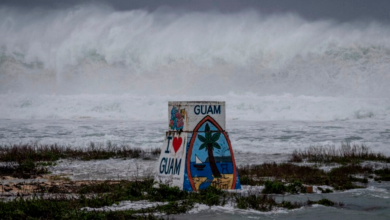
وعلى إثر هذا الحدث الجيولوجي الكبير، سارع مركز التحذير من أمواج تسونامي في المحيط الهادئ، والذي يتخذ من ولاية هاواي الأمريكية مقراً له، إلى إصدار إنذارات عاجلة. وحذر المركز من احتمال حدوث موجات مد عاتية (تسونامي) خطيرة في نطاق يمتد إلى 1000 كيلومتر من مركز الزلزال. وشملت هذه التحذيرات الاستراتيجية سواحل دول مجاورة عدة، أبرزها إندونيسيا، والفلبين، وماليزيا، مما دفع السلطات المحلية في تلك الدول إلى تفعيل خطط الطوارئ ومراقبة مستويات سطح البحر عن كثب.
السياق الجيولوجي: حزام النار في المحيط الهادئ
تأتي هذه الهزة الأرضية لتسلط الضوء مجدداً على الطبيعة الجغرافية والجيولوجية المعقدة لإندونيسيا. فالأرخبيل الإندونيسي يقع بالكامل تقريباً ضمن ما يُعرف بـ “حزام النار” في المحيط الهادئ. وتتميز هذه المنطقة بقوس مكثف من النشاط الزلزالي والبركاني المستمر، والذي ينتج عن اصطدام وتحرك الصفائح التكتونية الكبرى، مثل الصفيحة الأسترالية وصفيحة المحيط الهادئ والصفيحة الأوراسية. هذا الموقع الجغرافي يجعل إندونيسيا واحدة من أكثر دول العالم عرضة للكوارث الطبيعية المرتبطة بالزلازل والبراكين بشكل دوري.
خلفية تاريخية لكوارث الزلازل في المنطقة
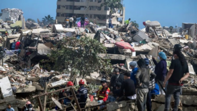
تاريخياً، عانت إندونيسيا من كوارث زلزالية مدمرة تركت بصمات عميقة في الذاكرة الإنسانية. ولعل أبرزها الزلزال الكارثي الذي ضرب قبالة سواحل جزيرة سومطرة في أواخر عام 2004، والذي بلغت قوته أكثر من 9.1 درجات. تسبب ذلك الزلزال في موجات تسونامي هائلة اجتاحت سواحل عدة دول مطلة على المحيط الهندي، مما أسفر عن خسائر بشرية ومادية هائلة. كما شهدت مدينة بالو في جزيرة سولاويسي عام 2018 زلزالاً وتسونامي أدى إلى دمار واسع، مما يؤكد الأهمية القصوى لتطوير وتحديث أنظمة الإنذار المبكر باستمرار.
التأثير المتوقع وأهمية التعاون الدولي
على الصعيدين الإقليمي والدولي، يبرز هذا الحدث أهمية التعاون الوثيق بين مراكز الرصد العالمية والسلطات المحلية. فالتأثير المتوقع لمثل هذه الزلازل لا يقتصر على النطاق المحلي الإندونيسي فحسب، بل يمتد ليشمل الأمن الإقليمي لدول جنوب شرق آسيا. إن سرعة تبادل المعلومات الجيولوجية الدقيقة، كما حدث بين هيئة المسح الجيولوجي الأمريكية والسلطات في الفلبين وماليزيا، تلعب دوراً حاسماً في تقليل الخسائر المحتملة، وتوجيه عمليات الإخلاء السريع للمناطق الساحلية المهددة، وضمان سلامة الملاحة البحرية في تلك الممرات المائية الحيوية.