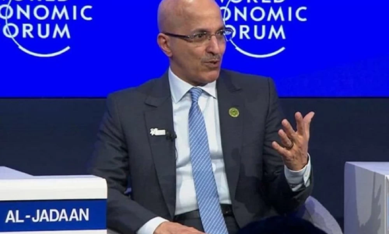
In a further affirmation of the strength of the strategic economic relationship between Riyadh and Washington, Saudi Finance Minister Mohammed Al-Jadaan settled the debate surrounding the future of Saudi investments in the United States. During his participation in the World Economic Forum "Davos 2026," Al-Jadaan categorically stated that there is no intention to change the Kingdom's investment stance in the American market, emphasizing his strong confidence in the strength and resilience of the American economy and its ability to continue growing.
Strategic partnership that transcends variables
These statements come at a time of major global economic shifts. In an interview with Al Arabiya Business, Al-Jadaan explained that the discussions with the American side, including his meeting with Scott Bisent, fall within the framework of ongoing and routine coordination with the US Treasury Department to follow up on joint agreements. He emphasized that these meetings are not isolated or ad hoc events, but rather part of the broader context of the deep historical relationship between the two countries.
These assurances are particularly significant given Saudi Arabia's economic weight as an active member of the G20, and the fact that Saudi investments in the United States are a cornerstone of bilateral relations. Historically, these relations have not been limited to the energy sector; under the Kingdom's Vision 2030, they have expanded to include technology, infrastructure, and bonds, reflecting Riyadh's long-term view of the US market as a safe and stable investment environment.
Focus on the essence and ignore the noise
In a message to investors and policymakers, the Minister of Finance stressed that the real challenge at present lies in being preoccupied with "media noise" at the expense of substantive issues. Al-Jadaan called for avoiding distractions that could negatively impact the quality of economic decisions, emphasizing the importance of focusing on economically controllable variables that can be effectively managed, rather than being swayed by speculation.
A new concept of financial sustainability
Regarding the Kingdom's domestic fiscal policies, Al-Jadaan corrected misconceptions surrounding the term "fiscal sustainability," clarifying that it does not necessarily mean austerity or reduced government spending. He emphasized that the Saudi strategy aims to "direct spending" and enhance its efficiency by allocating funds to high-quality projects capable of bringing about a genuine transformation in the structure of the economy and fostering sustainable long-term growth.
Al-Jadaan concluded his remarks by highlighting the strength of the Kingdom's financial position, noting that debt servicing as a percentage of non-oil revenues remains at very low and safe levels. He explained that the public debt strategy operates according to clear and strict parameters that are not exceeded, reflecting the success of the economic and financial reforms implemented by the Kingdom, which now offer valuable lessons and a rich experience that participating countries at the Davos Forum can benefit from.