Saudi Arabia weather today: Thunderstorms and flash floods in several regions
Weather forecast for Saudi Arabia on Thursday
Amid the current weather fluctuations in Saudi Arabia, the National Center for Meteorology issued its daily report detailing the weather conditions for Thursday. These periodic reports are of paramount importance both locally and regionally, as they contribute to raising public awareness and guiding citizens and residents to take necessary precautions, especially given the increasing rainfall that could impact transportation and infrastructure in various cities.
Heavy thunderstorms and flash floods
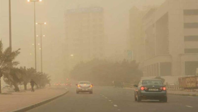
The National Center for Meteorology explained that thunderstorms of moderate to heavy intensity are expected to continue, potentially leading to flash floods in several vital areas. This rainfall will be accompanied by hail and active surface winds that will stir up dust and sand, reducing horizontal visibility. These forecasts cover large parts of the Makkah, Madinah, and Riyadh regions, as well as Qassim, Hail, Al-Jawf, Tabuk, and the Northern Borders region. Such rainfall is considered part of the typical weather pattern during seasonal transitions, where air masses collide, causing these weather phenomena.
Weather conditions in the southern highlands and the eastern region
On another note, the report indicated expectations of moderate rainfall in parts of the southwestern highlands, specifically in the Al-Baha, Asir, and Jazan regions, which are historically known for receiving higher rainfall rates compared to the rest of the Kingdom due to their unique geographical and mountainous nature.
In the Eastern Province, the center issued a special alert for light rain in its northern parts, specifically in Hafr al-Batin and Qaryat al-Ulya. This weather pattern is expected to begin at 1:00 PM and continue until 11:00 PM, accompanied by active winds and thunderstorms, with the possibility of fog that may reduce horizontal visibility in the early morning hours.
Maritime navigation situation: Red Sea and Arabian Gulf
Given the economic and commercial importance of maritime traffic in Saudi territorial waters, the report details the sea conditions to ensure the safety of fishermen and commercial vessels:
Red Sea
Forecasts indicate that surface winds will be southeasterly to easterly at speeds of 10 to 30 km/h in the northern part of the country. In the central and southern parts, winds will be southeasterly to southerly at speeds of 20 to 45 km/h, potentially reaching 50 km/h towards the strategic Bab el-Mandeb Strait. Wave heights are expected to range from half a meter to one and a half meters in the north, and from one to two meters in the central and southern regions, reaching two and a half meters near the Bab el-Mandeb Strait. This will result in slight to moderate sea conditions in the north and rough seas in the southern parts.
Arabian Gulf
For the Arabian Gulf, surface winds are expected to be northwesterly to westerly at speeds ranging from 20 to 40 km/h, reaching up to 45 km/h in the central and southern parts. Wave heights will range from one to two meters, potentially reaching two and a half meters, resulting in a moderate to rough sea state.
Safety and prevention guidelines
Given these weather forecasts, relevant authorities, primarily the General Directorate of Civil Defense, emphasize the need for caution and vigilance. It is always advisable to stay away from valleys and water bodies, and to adhere to official instructions to ensure the safety of lives and property. A rapid response to weather warnings plays a crucial role in mitigating the risks associated with flash floods and severe weather fluctuations.