تفاصيل زلزال بحر مالوكا في إندونيسيا
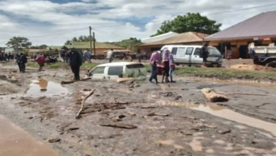
ضرب زلزال بقوة 5.8 درجة على مقياس ريختر منطقة بحر مالوكا الحيوية في إندونيسيا، مما أثار حالة من الترقب والمتابعة الدقيقة من قبل المراصد الجيولوجية العالمية والمحلية. ووفقاً للبيانات الرسمية الصادرة عن معهد المسح الجيولوجي الأمريكي (USGS)، فقد وقع هذا الزلزال على عمق يقارب 48 كيلومتراً تحت سطح البحر. وتمركزت بؤرة الهزة الأرضية على بُعد نحو 116 كيلومتراً شرق مدينة بيتنج الإندونيسية، وهي منطقة تقع جغرافياً بين مقاطعتي سولاويسي الشمالية وجزر مالوكا الشمالية. هذا العمق المتوسط للزلزال ساهم في تقليل حدة الاهتزازات السطحية المباشرة، إلا أنه يظل مؤشراً هاماً على النشاط التكتوني المستمر في المنطقة.
السياق الجيولوجي: لماذا تكثر الزلازل في إندونيسيا؟
لفهم طبيعة هذا الحدث، يجب النظر إلى السياق الجيولوجي الأوسع. تقع إندونيسيا، الأرخبيل الأكبر في العالم، بالكامل تقريباً ضمن ما يُعرف بـ ‘حزام النار في المحيط الهادئ’ (Ring of Fire). هذا الحزام هو قوس هائل يمتد على طول حوض المحيط الهادئ، ويتميز بنشاط زلزالي وبركاني كثيف للغاية. تنتج هذه الظواهر عن اصطدام وانزلاق الصفائح التكتونية الكبرى، وتحديداً الصفيحة الأوراسية، وصفيحة المحيط الهادئ، والصفيحة الهندية الأسترالية. هذا الموقع الجغرافي المعقد يجعل إندونيسيا واحدة من أكثر دول العالم عُرضة للكوارث الطبيعية، حيث تسجل آلاف الهزات الأرضية سنوياً، تتفاوت في قوتها وتأثيراتها.
الخلفية التاريخية للنشاط الزلزالي في المنطقة
تاريخياً، عانت إندونيسيا من زلازل مدمرة تركت بصمات عميقة في الذاكرة الإنسانية. لا يمكن الحديث عن الزلازل في هذا البلد دون استحضار كارثة زلزال وتسونامي المحيط الهندي عام 2004، والذي بلغت قوته 9.1 درجة وأسفر عن خسائر بشرية ومادية هائلة امتدت لتشمل عدة دول مجاورة. وفي عام 2018، تعرضت جزيرة سولاويسي، القريبة من موقع الزلزال الحالي، لزلزال عنيف بقوة 7.5 درجة تبعه تسونامي مدمر ضرب مدينة بالو، مما يؤكد على الحساسية المفرطة لهذه المنطقة الجغرافية وضرورة الاستعداد الدائم لمواجهة مثل هذه الطوارئ.
أهمية الحدث وتأثيراته المتوقعة محلياً وإقليمياً
على الصعيد المحلي، يضع زلزال بحر مالوكا الأخير السلطات الإندونيسية في حالة تأهب لاختبار كفاءة أنظمة الإنذار المبكر ومدى جاهزية البنية التحتية في مدينة بيتنج والمناطق المحيطة بها. وعلى الرغم من أن زلزالاً بقوة 5.8 درجة لا يؤدي عادة إلى حدوث موجات مد عاتية (تسونامي)، إلا أن الهزات الارتدادية المحتملة تتطلب حذراً شديداً من قبل السكان المحليين. إقليمياً، تتابع الدول المجاورة في جنوب شرق آسيا هذه التحركات التكتونية عن كثب، حيث تتبادل مراكز الرصد الإقليمية البيانات لضمان سلامة الملاحة البحرية والمناطق الساحلية المشتركة.
التأثير الدولي والاقتصادي
أما على الصعيد الدولي، فإن مراقبة هذه الزلازل تحمل أهمية علمية واقتصادية بالغة. علمياً، تساعد البيانات المستخرجة من هذه الهزات علماء الجيولوجيا حول العالم في تحسين نماذج التنبؤ بالزلازل وفهم حركة الصفائح الأرضية بشكل أدق. واقتصادياً، تُعد الممرات المائية الإندونيسية، بما فيها بحر مالوكا، شرايين حيوية للتجارة العالمية. أي نشاط زلزالي كبير قد يهدد الموانئ الرئيسية أو يعطل خطوط الشحن، مما ينعكس بشكل غير مباشر على سلاسل الإمداد الدولية. لذلك، يبقى التعاون الدولي في مجال الرصد والاستجابة للكوارث أمراً حتمياً لتقليل المخاطر المحتملة.